Colleagues, hello!
The problem to be solved- obtaining 100% reliable parameters for converting coordinates, for example, into the usual cartographic degrees (WGS84). Colleagues have already understood what I mean, but I will explain to the curious - the fact is that applications and algorithms walking on the Internet with parameters for recalculating coordinates, for example, from an extract of the USRN to your dacha into coordinates for a GPS receiver, will be overwhelmingly "bastards on a map." To search for an object the size of a house, this will not be a problem, but for an engineering venture, accuracy is already weak. For example, we want to mark terrain boundaries with centimeter accuracy, find a pipe underground or a cable, launch a drone using maps with flat coordinates, draw a drawing in flat coordinates with an online cartographic base from the Internet, and much more that requires sub-meter accuracy.
Why exact coordinates become inaccurate
The flat meter coordinates, familiar to us from information about our real estate or from projects and drawings, are very accurate locally, but mathematics alone is not enough to tie them to the globe. The fact is that the mathematical model of the "flat, meter" coordinate system from documents was first implemented on the ground in the form of geodetic points, with the accuracy of those technologies that were at that time (in the Russian Federation, most of the coordinate systems were developed in Soviet times and operate to this day). And only then, from these first-class geodetic points, others were created, from those still others, from all of them derived secret coordinate systems such as SK63 with turns and distortions of the coordinate grid in order to confuse the enemy. With each such transformation, distortions were allowed, insignificant, but they do not grow linearly with respect to the number of transformations,but much more progressive. As a result, most of the coordinate grids now look like a sheet slightly rumpled and pulled from one edge. That is why 99% of geo-calculators will not save you from the “crumpled sheet” of the coordinate grid. There are several geodetic services for recalculating coordinates, paid, I can assume that people there do not count according to the theoretical parameters of the coordinate system, but have all the parameters of the "crumpled sheet". In most of the Russian Federation, it is necessary to calculate the parameters of the coordinate system for small territories, the radius of these territories often does not exceed 15 km. In such small areas, the distortion of the coordinate grid often does not exceed a centimeter, the coordinate system very accurately "lies" on the globe. If your interest creeps out beyond 20-30 km of space, then you need to rely on several local parameters of the transition for smaller territories,split the coordinate system into smaller subzones.
Reinventing the bicycle?
For the purpose of calculating the true parameters of the coordinate systems, it turns out to be a "car" of the software. True, these are usually components of complex and expensive professional software systems for geodesy and cartography, which not all professionals even need, some of the software runs on Windows with incomprehensible and difficult to use file formats. There are more command line options. Inspired by an article on a profile forum, we decided to write our own software with blackjack and the web.
I'll tell you briefly how it works
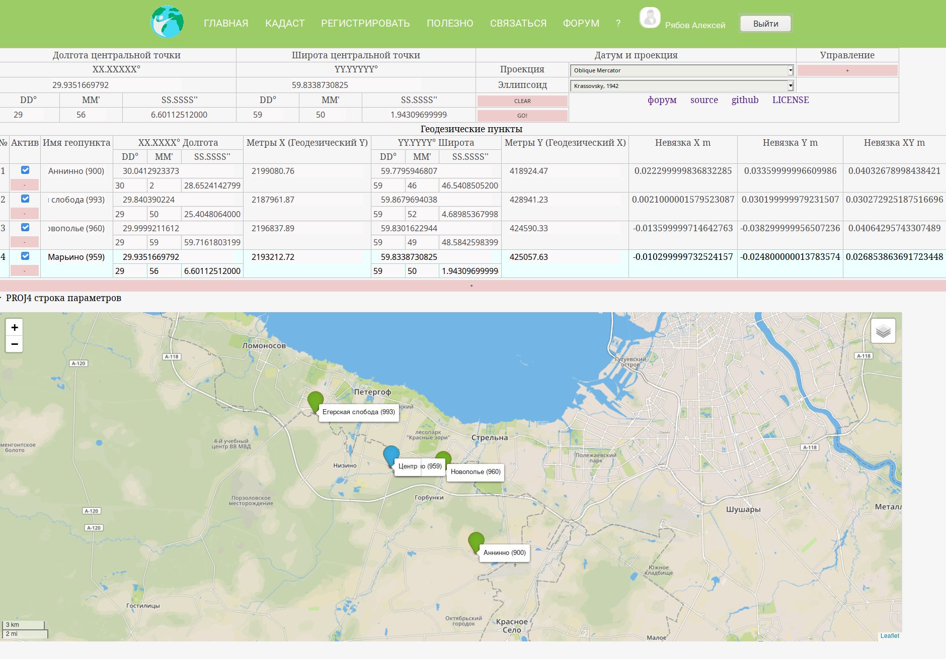
To calculate the parameters, we need three points (as many as possible, it will be more accurate) in two coordinate systems, in the WGS and in the same local coordinate system, the parameters of which you want to know. We take flat meter coordinates from catalogs, cadastral plans of territories, reference cards, etc. Degree coordinates or from the same sources, or we often use the coordinates of GNSS base stations, or we take a satellite receiver, and simply measure these points known in plane coordinates.
The web form calculates the parameters of the coordinate system and displays it in two popular formats that are applicable in 99% of GIS systems - proj string and WKT.
Here are a few stories about the very parameters and a little terminology
Many incomprehensible letters
, . x,y,z lat long h. h , , , ( ).
— «». , . , , .
() — , . , , ..
, . PROJ4 (MapInfp, ArcGIS . . , ): +proj=omerc +lat_0=59.8338730825 +lonc=33 +alpha=-0.0001 +gamma=-1.771957267229058 +k=0.9996584453038837 +x_0=2365031.423134961 +y_0=426397.2888527482 +ellps=krass
(+ellps=krass)— . : , , . . . , 42 .
(+proj=omerc) — . « », , .
. , , , . . . , 42 . (omerc).
(+lat_0=59.8338730825 +lonc=33) — , « » ( ), . . .
(+alpha=-0.0001 +gamma=-1.771957267229058) .
(+k=0.9996584453038837), . , . , .
(+x_0=2365031.423134961 +y_0=426397.2888527482), .
Open source packages are taken as a basis -
- proj4 for geodetic transformations
- Leaflet to display information on the map
- geophp for calculating the area of effect of parameters with centimeter accuracy (at the time of this writing, not implemented)
The source code of the web form is available under the AGPL license in the open repository .
Discussion of the web form of the tutu